


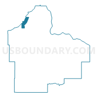
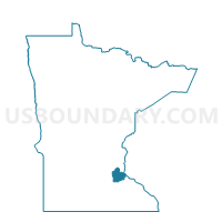
Eagan P-4, Dakota County, Minnesota
About
Outline

Summary
| Unique Area Identifier | 601728 |
| Name | Eagan P-4 |
| County | Dakota County |
| State | Minnesota |
| Area (square miles) | 4.52 |
| Land Area (square miles) | 3.92 |
| Water Area (square miles) | 0.60 |
| % of Land Area | 86.66 |
| % of Water Area | 13.34 |
| Latitude of the Internal Point | 44.83978380 |
| Longtitude of the Internal Point | -93.19922030 |
Maps

Graphs
Select a template below for downloading or customizing gragh for Eagan P-4, Dakota County, Minnesota


Neighbors
Neighoring Voting District (by Name) Neighboring Voting District on the Map
- Bloomington W-4 P-1, Hennepin County, MN
- Burnsville P-1, Dakota County, MN
- Burnsville P-10, Dakota County, MN
- Eagan P-1, Dakota County, MN
- Eagan P-12, Dakota County, MN
- Eagan P-13, Dakota County, MN
- Eagan P-14, Dakota County, MN
- Eagan P-2, Dakota County, MN
- Eagan P-5, Dakota County, MN
- Eagan P-6, Dakota County, MN
- Eagan P-7, Dakota County, MN
- Fort Snelling Unorg. P-1, Hennepin County, MN
- Mendota Heights P-3, Dakota County, MN
Top 10 Neighboring County Subdivision (by Population) Neighboring County Subdivision on the Map
- Bloomington city, Hennepin County, MN (82,893)
- Eagan city, Dakota County, MN (64,206)
- Burnsville city, Dakota County, MN (60,306)
- Mendota Heights city, Dakota County, MN (11,071)
- Fort Snelling UT, Hennepin County, MN (149)
Top 10 Neighboring Place (by Population) Neighboring Place on the Map
- Bloomington city, MN (82,893)
- Eagan city, MN (64,206)
- Burnsville city, MN (60,306)
- Mendota Heights city, MN (11,071)
Top 10 Neighboring Unified School District (by Population) Neighboring Unified School District on the Map
- Rosemount-Apple Valley-Eagan School District, MN (143,932)
- Bloomington Public School District, MN (82,887)
- Burnsville Public School District, MN (67,370)
- West St. Paul-Mendota Heights-Eagan School District, MN (42,099)
- School District Not Defined, MN (144)
Top 10 Neighboring State Legislative District Lower Chamber (by Population) Neighboring State Legislative District Lower Chamber on the Map
- State House District 40A, MN (38,017)
- State House District 63B, MN (37,315)
- State House District 38A, MN (36,837)
- State House District 39A, MN (36,477)
Top 10 Neighboring State Legislative District Upper Chamber (by Population) Neighboring State Legislative District Upper Chamber on the Map
- State Senate District 39, MN (77,255)
- State Senate District 63, MN (74,746)
- State Senate District 40, MN (73,674)
- State Senate District 38, MN (73,200)
Top 10 Neighboring 111th Congressional District (by Population) Neighboring 111th Congressional District on the Map
- Congressional District 2, MN (732,515)
- Congressional District 3, MN (650,185)
- Congressional District 5, MN (616,482)
- Congressional District 4, MN (614,624)
Top 10 Neighboring Census Tract (by Population) Neighboring Census Tract on the Map
- Census Tract 607.35, Dakota County, MN (4,830)
- Census Tract 607.50, Dakota County, MN (3,832)
- Census Tract 607.47, Dakota County, MN (3,760)
- Census Tract 607.16, Dakota County, MN (3,690)
- Census Tract 607.25, Dakota County, MN (3,461)
- Census Tract 607.48, Dakota County, MN (3,459)
- Census Tract 251, Hennepin County, MN (2,570)
- Census Tract 607.26, Dakota County, MN (2,546)
- Census Tract 607.21, Dakota County, MN (2,211)
- Census Tract 606.05, Dakota County, MN (1,593)
Top 10 Neighboring 5-Digit ZIP Code Tabulation Area (by Population) Neighboring 5-Digit ZIP Code Tabulation Area on the Map
- 55337, MN (44,356)
- 55122, MN (30,346)
- 55425, MN (8,952)
- 55121, MN (7,861)
- 55120, MN (4,352)
- 55111, MN (0)